Introduction
In this module we will be addressing two main subjects, which are sadly lacking in most pleasure yachtsman’s experience – Pilotage and the International Rules for Prevention of Collisions at Sea (IRPCS). In coastal situations, a lack of knowledge of one or both of the above is the cause of most groundings and collisions.
We will also deal with Passage Planning and Pollution.
First let us define the term, to distinguish pilotage from the related subject of navigation.
You are piloting if you can see your
next mark, and you know exactly where you are.
You are navigating if
you can’t and don’t.
Most folk could find their way across an ocean without crashing. There’s
nothing to hit!
Put them near the land and it’s a different story.
Here are a few simple rules that I use when I have to pilot into or out of a new (to me) area. They are not in order and you don’t always use all of them.
When running practical courses, my students always amaze me, by trying to pilot into a harbour using the same chart that we have just crossed the English Channel with!
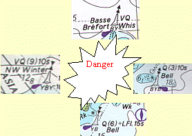
Generally speaking, if you sail into a Magenta box then it’s time to change the chart you are using. These boxes are there to tell you that there is a better scale chart for the area.
See Training chart 2: Dartmouth Harbour.
There’s a box around the harbour, with the chart number in the bottom right and top left corners. I am afraid that you do not have that chart, but there is a drawing with a similar scale on page 30 of the Practice Navigation Tables (PNT). You can see that there is far more detailed information about lights, buoys, pontoons, depths, ferries etc.
Charts are expensive, but life is so much easier, not to mention safer with good chart coverage.
Some yachtsman’s charts have harbour and "tricky spots" insets around the margins. This can save a few dollars. They are often not as detailed as the Admiralty equivalent.
lots knocked out here
There are five criteria, which govern "safe speed" within the IRPCS. (Have a look) These always need to be considered whatever you are doing. A safe speed in terms of pilotage is one that you can cope with. If you are in a tight area or a complicated pilotage, you may need to slow down accordingly. There are times when you will need to be at full speed. If you have to enter a harbour against a spring ebb tide, you will be struggling to go forwards even then. If the tide is with you, it can give you too much speed. So much in fact that you may have your engines in astern.
You can set your speed to whatever you like, within defined speed limits, so set it to a speed which is easy to calculate.
E.g. 6 knots, means you will cover 1 mile in ten minutes.
4 knots is 1 mile in 15 minutes.
3 knots is 1 mile in 20 minutes.
All easy numbers. Don’t use 5 knots; it’s too hard when your brain is busy enough.
Bear in mind that the tidal stream does not show on your log – you will need to allow for it when estimating your ground speed.
IF YOU ARE NOT SURE - STOP
I’m told that you cannot stop in a boat. That is true, but you can slow so that you run aground at one knot instead of steaming in at 6 knots!
If you get lost then stop. Turn into the tide and stem it, i.e. go as fast as the tide in the opposite direction. You can then take stock of the situation and if necessary go back to your last mark and start again.
If you cannot see your last mark you are not piloting, you are navigating! You can sometimes stop and grab a free mooring for ten minutes while you re-plan.
| CRUCIAL STUFF! |
|
The International Association of Lighthouse Authorities (IALA) has come up with a system of buoys, which are used virtually worldwide. There are two regions, A and B. Region A is the whole of Europe and that is what we will cover. When you go sailing in the States, give me a call first! That’s region B. The system is made up of 5 types of buoy. These buoys can be recognised in a number of ways: - shape, top mark, colour, light character and colour.
CARDINALS
| Just like the four cardinal points of the compass, so there are 4 of these. They tell us how to stay in the safe water around a danger. E.g. always stay north of a North Cardinal bouy. On charts they look something like this. As you can see they all have a black top mark. North and south are easy, but east and west are harder to remember. "West is like a waist" is how I remember it. Underneath each buoy, you will see some letters. They are telling you the painted colours of the buoy. The West Cardinal is YBY, yellow black yellow. The arrows on the top marks point to the black. The two arrows are pointing into the middle, so the black is in between the two yellows. |
 |
All these buoys are also lit. The magenta teardrop tells us this.
Lots knocked out here
International Regulations for the Prevention of Collisions at sea.
There is a set of rules that govern power driven vessels on collision course with other powered craft and a set for sailing vessels on collision courses with other sailing vessels.
Vessels under power
There are three rules, which govern who should give way to who when two power driven vessels are on a collision course.
|
1, In a head-on situation, both boats must turn to starboard. Like driving in France or the USA, you keep to the right. |
 |
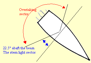
| 2, Over taking vessels must give way. You are
overtaking if you can see any athwart ships bulkhead or at night a stern
light. There is an angle for this. You are overtaking if you are on or
more than 22.5° abaft the beam. This is where the
stern light sector starts. (Again, bear with me; I’m coming to lights)
The overtaking vessel does not become a crossing vessel when she is half
way past. She must keep clear until she is past and clear.
|
|
|
|
|
|
3, Crossing vessels. This one is also easy, but if you mix it up it is catastrophic! Arriving at a roundabout in the UK we give way to vehicles on our right. It is the same at sea. If you have a vessel on a collision course in the sector from ahead to 22.5° abaft the beam, on your Starboard side (right), you must give way. This is the green navigation light sector. |
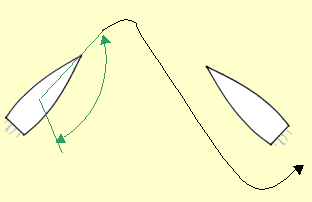 |
You can give way by any means, but preferably by altering course to starboard and therefore passing around the stern.
"If to starboard red appear, tis your duty to
keep clear".
Conversely, if you have a vessel on your port side you must
stand on.
| CRUCIAL STUFF! |
When under power:
|
Sailing vessels
There is a different set of rules for two sailing vessels on a collision course and they must never be confused with the rules above. One rule is used for all vessels. "The overtaking vessel keeps clear".
There are three other rules for sailing vessels. They are very different as they use the wind, rather than the relative position of the two boats, to determine who does what. First we need to know a bit about the wind and sailboats. But you will have to wait and see!