NB, Only a sample, lots chopped out
Introduction
In this module we will be addressing two main subjects, which are sadly lacking in most pleasure yachtsman’s experience – Pilotage and the International Rules for Prevention of Collisions at Sea (IRPCS). In coastal situations, a lack of knowledge of one or both of the above is the cause of most groundings and collisions.
We will also deal with Passage Planning and Pollution.
First let us define the term, to distinguish pilotage from the related subject of navigation.
You are piloting if you can see your
next mark, and you know exactly where you are.
You are navigating if
you can’t and don’t.
Most folk could find their way across an ocean without crashing. There’s
nothing to hit!
Put them near the land and it’s a different story.
Here are a few simple rules that I use when I have to pilot into or out of a new (to me) area. They are not in order and you don’t always use all of them.
lots chopped here
Don’t guess: PLAN.
I often see skippers with the chart in the cockpit, trying to pilot. This method does not work! Once you have started your pilotage you must keep your eye on where you’re going. You have no time for messing about with the plotter. (Have you ever tried reading a map while driving in Central London!!!)
A good tip is to draw a map rather than write notes. A picture will show you what and where, much faster than reading through notes. You often don’t have time to write it all down, but a quick sketch will do the job.
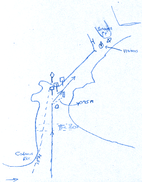 This
"masterpiece"? could get me into Salcombe from the west.
This
"masterpiece"? could get me into Salcombe from the west.
Have a look at the plan on page 27PNT.
- We will first use Cadmus rocks to "Positively Identify" Sandhill Pt beacon. (It will not be easy to see from seaward, at more than a mile off). When Cadmus bears 015° M, the beacon will appear around the rocks on the same bearing.
- Once we have identified it, we keep moving east until our beacon bears 005° M, when it will come into "Transit" with the first of three red and white beacons with square top marks. We run towards it.
- When we have left the green buoy to starboard, we slow down and look for the green beacon on our starboard side. When this beacon bears 095° M, we turn right and stay in the middle of the channel at about 050° M.
- As we go northeast, we will see a small pier sticking out on the left, with a bay opening out behind it. The visitors’ moorings are just past the pier. If we arrive at the lifeboat, we have gone too far and need to back track.
Using a plan like this, we know where we are at all times.
Note that I have converted bearings to Magnetic. This is important. If you make an easy mistake like subtracting the variation instead of adding it when you are busy with implementing your plan, you will crash. I’ve done it! Convert to magnetic while you are relaxed and have time.
The skipper should do as little as possible when bringing the boat in.
Plan ahead and delegate.
This subject brings in many skills, from making sure you have the kid’s toys to a battery drill and rivet gun. Somewhere in between comes the weather forecast and charts.
Well before the day you want to sail, in the comfort of home, have a good look at the passage you want to make.
- Have you got enough charts for the passage and pilotage?
- How far is it? How fast do we sail? Will we need to run a night watch or is it an easy day sail?
- Where are the likely dangers, tidal gates, (headlands, drying harbours etc)
- You should also work out the tides so that you know what time you must leave by, and when you have to round that headland to miss the overfalls.
- If you have to divert because someone is sea sick, or the weather turns bad, where can you run to find shelter. You can read all about the route and the harbours from the various pilot books available.
- Do a few simple pilotage plans for the likely harbours, including the ports of refuge.
- Make a plan for provisioning and gear needed, so as to be as prepared as possible.
- Is our crew strong enough and does it have enough experience for the trip. Does it want to go?
- Don’t make a decision without consulting the family! The kids no doubt would like to play on the beach instead, so you may have to sail at night when they’re asleep!
- Does the Coastguard have our CG66 and is it up to date? (See module 6 Logging With The Coastguard).
- Can the boat cope with the passage? This is a big question which you must answer yourself. Some small boats do sail across oceans. If they make it, they are well prepared in every respect. If they don’t, they were not! See stability.
- Customs procedures. If you are going to a destination outside EC waters from an EC country then you will need to collect a customs form from the Customs office or in marina offices normally. These forms change periodically so there is no point in me trying to tell you how to fill it in. Just follow the steps on the form. When you reach the territorial waters of the foreign country, carry out the customs procedure for that country. This can be found in sailing directions, but normally flying the "Q" flag and proceeding to the customs clearance port and area.
International Regulations for the Prevention of Collisions at sea.
There is an international agreement between maritime nations to make the IRPCS regulations cover all the oceans.
The "Highway Code" is the set of rules that you must obey when you are driving a car. The IRPCS are very similar, with two major differences.
First as I said, they operate worldwide. Secondly, there is a police force making sure we all keep to the rules on the road. At sea that is impossible. The only way to make sure everyone sticks to the rules is to have very heavy penalties should an accident occur. For example, on the road, if you knocked down a pedestrian you might lose your licence. At sea if you committed a similar offence, you would lose your licence and be sent to prison.
Every master of every vessel must know and apply the rules, from a rowing boat to a Super tanker, from a tidal river to the Atlantic.
There is a very good pamphlet called simply "G2", available from the RYA for about £3 or £4, which will help you with this subject and it is well worth getting because like most information, you only retain it if you use it. Keep the booklet on board for when you need it.
I will attempt to give you the bare essentials of the rules as they apply to the yachtsman.
First a couple of definitions
Underway is a vessel which is not attached to the
bottom or a quay.
Making way is a vessel which is moving through the water.
Stopped a vessel which is underway but stopped
Lots chopped out here but here's a sample
Sailing vessels
| 3, If you are close hauled on a PORT tack on
a collision course with a boat to windward of you, and the tack of the
other vessel is unclear - give way.
This is a tricky rule to write down! I’ve been teaching it for years, but I still haven’t found a short way of explaining it! This rule has become more important due to the introduction of deck sweeping headsails and large, low footed spinnakers. It has always been used at night of course as we cannot see sails then! If you are the boat going to windward, not only is it hard for you to establish what tack the other boat is on, but also the boat coming downwind might not have seen you, as you are obscured by her sails. |
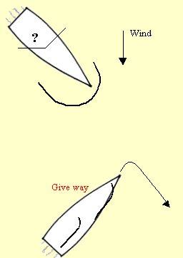 |
There are two possibilities here.
1, The vessel close hauled on port tack (you) might be the give way vessel, if the boat to windward is on starboard tack. (Port and starboard tack rule)
2, The vessel to windward might be the give way vessel, if she is on port tack. (Windward boat rule).
There is a conflict here, so we use the "unclear tack rule".
The boat close hauled on the port tack must alter course earlier than normal, because the boat to windward may alter at the same time creating a "two men in a doorway" fiasco.
Normally when going to windward, trying desperately to claw our way home, the last thing we want to do is to run down wind again! Ground to windward is hard won!
But in a close quarters situation, that is our only choice.
If we tack, the boat to windward may gybe at the same time! There will not be enough time and distance left to avert a collision. Remember when you are gybing and tacking, sails are flogging about and we are not concentrating on the other vessel. We are not expecting her to have altered as well, and bang! By bearing away down wind, we are altering course to starboard and making ourselves a small target and easy to avoid.
I have said that the give way vessel should alter course early. If you have plenty of space, then by all means tack and carry on beating. That is not always possible, I’m afraid.
I was once beating back through the Alderney race in the dark, aboard a 60’ Schooner, on a port tack at the time. It was a bad night, with a rough sea and raining. Suddenly I saw a green light on my port bow. In other words, there was another sailing vessel upwind of us, the very situation I have been talking about. Yes; it happens in the dark too! She was very close, perhaps 200 yards off. I threw the wheel over and tacked. This was a large charter yacht with only my wife and myself aboard. She had four sails to get across and they were big for two people. When I looked up from my task I was horrified to see a 40’ yacht come sliding down my starboard side, so close that I could see the helmsman’s face in the light from his compass light, just a few feet away! He had gybed as I tacked. Our combined speed was about 20 knots and if we had collided, I would not be writing this!
What did I do wrong?
I did not use "good seamanship". I did not think about what the other guy might do. He was on a port tack, so quite rightly went to pass around my stern. At the last moment he crash gybed back onto port tack to miss us.
What should I have done?
Bore away down wind. Next time I will, you can be sure of that and I hope you will remember and do it too!
Another point comes out of this. It would be useful in a big sea if yachtsmen would use high navigation lights, like a "tricolour", rather than silly little pulpit mounted bi-colours, which spend most of their time under water. These only contribute towards the risk of collision, by making yachts virtually invisible in bad weather. In this case, though, we were showing navigation lights and sailing lights at the masthead. I don’t know why our friend did not see us and take action earlier.
OK, enough wittering on! Back to work.
feel I must say a few words about AIS (Automated Identification system) at this point.
Over the last few years, lets say ten. I have been increasingly aware when crossing busy shipping areas eg the English Channel. At the increase in the speed of ships. Fifteen years ago most ships were moving at perhaps 12 to 15 knots. It is not uncommon for them to be making 25knots in 2007.
Here is a picture of a screen print from our AIS receiver to demonstrate the problem
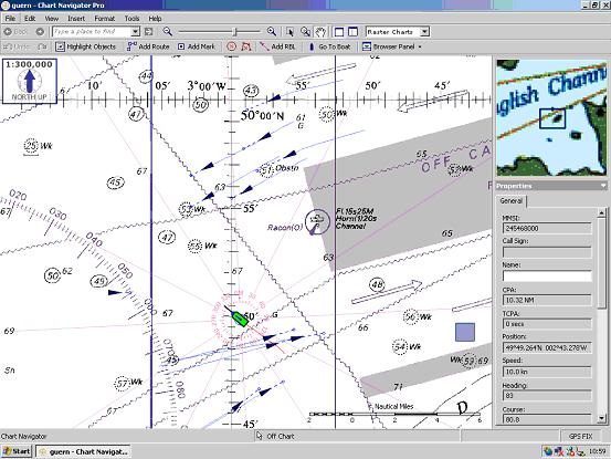
We are the green boat. We are making about 7.5 to 8 knots. With AIS you can
click on a target vessel and its Name, MMSI number, course speed and position
flick up on the side screen ( sorry the picture is not very good) We are
also and most importantly given its closest point of approach
Most of these ships were making about 20 knots! I only had one on a
collision course. I was able to contact her using her MMSI number and she
agreed to alter around our stern.
We had good visibility, but none the less this system gives the small craft
skipper a lot of confidence and takes off a lot of strain. Bear in mind
that a ship making 24 knots in visibility of 2 miles, will be upon you in 5
minutes!
She covers a mile in 2.5 minutes!